Introduction
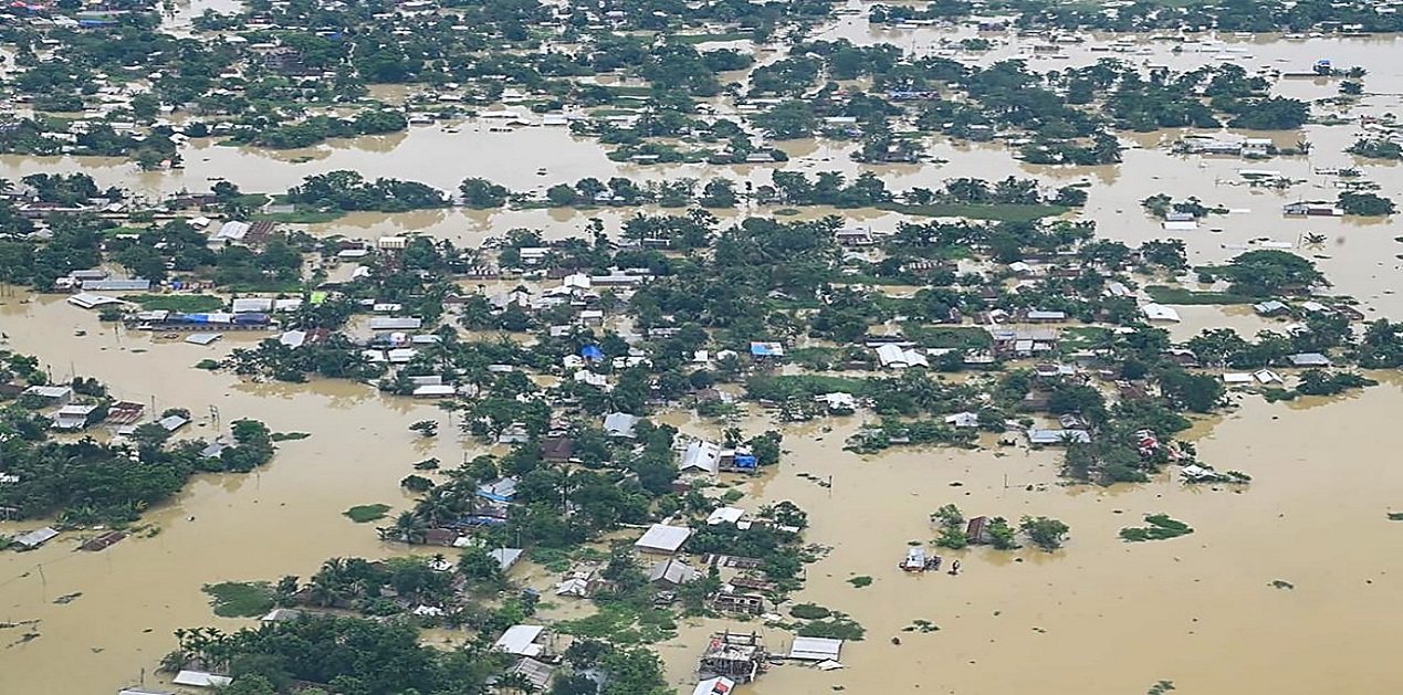
North-east India has been witnessing unusually heavy rainfall since the beginning of May. That has resulted in one of the worst floods ever recorded in Assam. As of 3 July, flood has affected 1,835,551 people in 26 out of the state’s 35 districts and it submerged 471.98 square kilometers (47,198.87 hectares) of cropland.[1] About 200 people have died so far. Earlier on 22 June the floods had affected 5,457,601 people in 32 districts and submerged 990.26 square kilometers (99,026 hectares) of cropland.[2] Recurring floods in Assam and their devastating impacts has raised serious questions about the efficacy of current flood adaptation measures that relies primarily on grey infrastructure (or engineering solutions) such as embankments. As floods are projected to intensify as the world gets warmer, a combination of grey infrastructure and green infrastructure (or nature-based solutions) can help Assam and other flood-prone states of India adapt to its impact more effectively in the coming years.
Floods and its Impact on Assam
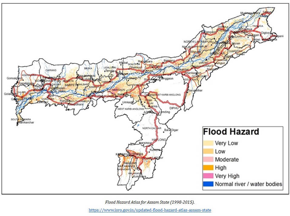
Assam is one of the most flood-prone states in India and it experiences up to three to four waves of flooding every year. In all, 31,050 square kilometers (3,105,000 hectares) or 39.58% of its total land area is vulnerable to flooding each year.[3] Assam’s vulnerability to flood stems from a complex web of climatic, hydrological and social factors. The state is located in a region that is known for extreme rainfall. For example, while India received an average rainfall of 61.1 millimeters during the first 17 days of the current monsoon season from 1-17 June, the north-east region received 220.3 millimeters, 39% above normal. [4] In contrast, northwest India, central India and southern India reported deficit rainfall of 63%, 57% and 24% respectively. The high density of rivers further exacerbated Assam’s vulnerability to floods. The state has over 125 rivers, a significant numbers of which originated from the hills and mountains of Arunachal Pradesh and Meghalaya (both extreme rainfall hotspots) as well as countries like Bhutan and China. The most well-known among these rivers is the Brahmaputra which originated as the Yarlung Tsangpo in Southwest Tibet. Beyond this, a combination of other factors such as poor or inadequate drainage/channel capacity, high silt load in rivers, encroachment of riverine areas, deforestation/watershed degradation, loss/destruction of wetlands, corruption, etc. have contributed to Assam’s flood woes. Floods have a significant negative impact on Assam’s economy as it loses an estimated Rs. 200 crores every year due to it.[5] This is probably an underestimate and the true economic costs of floods are likely to be many times higher. Furthermore, floods have also washed away 4,270 square kilometers (4,27,000 hectares) of land or 7.40% of the Assam’s total land area since 1950. It continues to wash away 80 square kilometers (8,000 hectares) of land every year. It has also destroyed critical infrastructures that are essential for the maintenance of vital societal functions such as roads, bridges, railway tracks, etc.
Limitations of Current Adaptation Measures
As is the case with other flood-prone states in India, grey infrastructure - so called because it is usually built with concrete - such as embankments (also known as levees or dykes) are the preferred form of flood adaptation in Assam. Embankments are walls constructed along the banks of rivers to prevent flooding. According to reports, since the 1950s, Assam has built 423 embankments along the Brahmaputra River and its tributaries.[6] Of these, 295 are believed to have outlived their intended lifespan. It is therefore not surprising that they are being breached regularly and are even damaged and destroyed. During the post-flood reconstruction phase, government agencies often resorted to simply fixing damaged or destroyed embankments and do not build them back better. As such, they continue to remain vulnerable to future floods. Embankments themselves are also known to exacerbate Assam’s flood problems. For example, floods caused by embankment breaches are often more severe than the regular flooding of rivers and it spread over a more expansive area. Embankments also obstruct flood waters from retreating back into rivers once floods have subsided. Despite these limitations, Assam continues to remain fixated on embankments. One major reason for this is the vested interests of engineers, contractors and politicians for whom embankments are “big business.” Alluding to this, one expertopined that “Assam has increasingly moved towards becoming an ‘embankment economy’ - the construction of embankments along the Brahmaputra has become a business involving contractors for construction, maintenance and repair.”[7] He further lamented that “Floods actually mean a lot of money to a lot of people and many feed off the contractor lobby.”[8]
Rethinking Adaptation
The International Panel on Climate Change (IPCC) observed in the first installment of its Sixth Assessment Report (AR6) that was released on 9 August 2021 that “…the frequency and intensity of heavy precipitation events have increased since the 1950s over most land area” and that “human-induced climate change is likely the main driver.”[9] Thus, as climate change tips toward full-blown crisis, north-east India faces the prospect of more extreme rainfall. For Assam, that meant more intense and severe flooding. In the face of this challenge, a diversified approach to flood adaptation that included both grey and green infrastructures should be explored. In other words, both engineering solutions and nature-based solutions should be a critical part of Assam’s flood defence toolbox. Nature-based solution is an umbrella term that refers to “actions to address societal challenges through the protection, sustainable management and restoration of ecosystems, benefiting both biodiversity and human well-being.”[10] Such solutions may include the following:
- Protecting, restoring or managing natural forests in catchment areas (in upstream/headwaters and along rivers): Upstream forest slows and retains surface water runoff. It also reduces soil erosion and landslides.
- Protecting and restoring wetlands: Wetlands act as natural sponges. They absorb floodwaters during wet periods and release them during dry periods.
- Maintaining or enlarging natural floodplains: Floodplains are natural flooding outlets for rivers and provide more room to spread out.
Implementing these could prove to be challenging because it will require actions to be taken across jurisdictional boundaries. For example, managing floods in the Brahmaputra River effectively through nature-based solutions will necessitate the adoption of a basin-wide approach. That in turn will require greater cooperation and coordination of efforts between Assam, Arunachal Pradesh, Meghalaya and other neighbouring states. However, the priorities, interests and values of these states may not align necessarily and may even be in conflict with each other. But this is not completely insurmountable. Although Arunachal Pradesh andMeghalaya are less vulnerable to flooding than Assam owing to their hilly terrain, they are highly vulnerable to extreme rainfall-induced landslides and mudslides. Given this, it is imperative that Assam and its neighbouring states convene a regional plan to jointly address the challenges of not only floods but also landslides and mudslides sustainably through nature-based solutions.
Conclusion
The ongoing floods in Assam should be seen as a wake-up call that finally galvanizes action on adaptation. Although engineering solutions such as embankments still have a role to play in mitigating floods, they are no longer sufficient. Nature-based solutions therefore have an obvious place in Assam’s flood defence toolbox and provide a powerful complement (or alternative) to engineering solutions. Working alongside engineering solutions, nature-based solutions will boost the overall resilience at all levels of flooding.
Endnotes :
[1] “Assam Daily Flood Report as on 03-07-2022 at 4:00 PM.” Flood Reporting and Information Management System (FRIMS). Assam State Disaster Management Authority (ASDMA). July 3, 2022.
http://www.asdma.gov.in/pdf/flood_report/2022/Daily_Flood_Report_03.07.2022.pdf
[2] “Assam Daily Flood Report as on 17-06-2022 at 4:00 PM.” Flood Reporting and Information Management System (FRIMS). Assam State Disaster Management Authority (ASDMA). June 22, 2022.
http://www.asdma.gov.in/pdf/flood_report/2022/Daily_Flood_Report_22.06.2022.pdf
[3] Ministry of Jal Shakti, Department of Water Resources, River Development and Ganga Rejuvenation. 2021. “Flood Management in the Country including International Water Treaties in the field of Water Resource Management with particular reference to Treaty/Agreement entered into with China, Pakistan and Bhutan.” Standing Committee on Water Resources (2020-2021). Seventeenth Lok Sabha. Lok Sabha Secretariat. August. New Delhi.
http://164.100.47.193/lsscommittee/Water%20Resources/17_Water_Resources_12.pdf
[4] Kalita, Prabin. “Northeast rain: ‘Wettest places on earth’ live up to reputation with highest rain in 56 years.” Times of India. June 18, 2022.
https://timesofindia.indiatimes.com/city/guwahati/wettest-places-on-earth-live-up-to-reputation-with-highest-rain-in-56-yrs/articleshow/92265984.cms
[5]“Assam Losing ₹200 Crore Annually Due to Floods: Economic Survey.”NDTV. August 20, 2014.
https://www.ndtv.com/india-news/assam-losing-rs-200-crore-annually-due-to-floods-economic-survey-650610
[6]“Banking on national embankment policy.” The Sentinel. April 5, 2022.
https://www.sentinelassam.com/editorial/banking-on-national-embankment-policy-586094
[7]Sharma, Ashima. “The Mising and the Miyah have learnt to live with the Brahmaputra. Can Assam?” The Third Pole. September 30, 2021.
https://www.thethirdpole.net/en/livelihoods/adapting-to-brahmaputra-floods-assam-mising-miyah/
[8] Karmakar, Rahul. “In Assam, a trail of broken barriers.” The Hindu. August 2, 2020. https://www.thehindu.com/news/national/other-states/in-assam-a-trail-of-broken-barriers/article32244695.ece
[9] International Panel; on Climate Change (IPCC). 2021. “Summary for Policymakers.” In: Climate Change 2021: The Physical Science Basis. Contribution of Working Group I to the Sixth Assessment Report of the Intergovernmental Panel on Climate Change [Masson-Delmotte, V., P. Zhai, A. Pirani, S.L. Connors, C. Péan, S. Berger, N. Caud, Y. Chen, L. Goldfarb, M.I. Gomis, M. Huang, K. Leitzell, E. Lonnoy, J.B.R. Matthews, T.K. Maycock, T. Waterfield, O. Yelekçi, R. Yu, and B. Zhou (eds.)]. Cambridge University Press, Cambridge, United Kingdom and New York, NY, USA, pp. 3−32. https://www.ipcc.ch/report/ar6/wg1/downloads/report/IPCC_AR6_WGI_SPM.pdf
[10] International Union for Conservation of Nature (IUCN). 2020. “Ensuring Effective Nature-based Solutions.” Issues Brief. July.
https://www.iucn.org/sites/default/files/2022-02/iucn_issues_brief_-_nbs_standard_eng.pdf
(The paper is the author’s individual scholastic articulation. The author certifies that the article/paper is original in content, unpublished and it has not been submitted for publication/web upload elsewhere, and that the facts and figures quoted are duly referenced, as needed, and are believed to be correct). (The paper does not necessarily represent the organisational stance... More >>
Image Source: https://www.thehindu.com/news/national/assam-floods-a-first-person-account-the-day-a-town-drowned/article65557462.ece

-

The return of Donald Trump to the White House in 2025 has signifi
-

I would like to thank RIAC and the embassy of India for inviting
-

This war is not about Russia and Ukraine as much as between Russi
-

Recent media reports have highlighted the growing menace of GPS S
-

Introduction Eighty years after the March 1945 bombing of Toky
-

(Given below is the keynote address delivered by Brig Vinod Anand
-

Since Donald J. Trump’s start of second term as US president, h
-

कुम्भ मेला – एक परिचय कु
Post new comment